Trip notes for Freshwater East – where we went, where we started and weather and tide notes
A trip along superb coastline
Starting at Freshwater East
We had to travel to West Wales and decided to make the most of it and take the kayaks. You know how it is, we planned to be on the water by late morning, the meeting took longer and then we we discovered the absolute gridlock of holiday traffic, roadworks and goodness knows what else in Pembroke town. Note to self: AVOID in Summer! Change to plan B.
Second, be aware that parking at Stackpole Quay is very limited and was full even on a Monday in the middle of August. Plan C?
Certain that we would find somewhere to launch we continued along the minor road to Freshwater East. Here we found a car park on the left (with space! £5.00 for the day!!!) and, better still, a small track opposite which lead up past some houses to the top of a slipway. There is no parking here and not advisable to drive onto the sand, but we were able to unload the boats right on the beach and then go back to park the van.
Sea not too far away!
We arrived knowing that the tide would be ebbing, and I had flash-backs to very very long carries at Oxwich, but the beach has a better gradient here, so the sea didn’t disappear too far away.
Weather and tide
We were paddling on an ebbing tide so we decided to leave Freshwater East and paddle with the tide to start with and head towards Stackpole and Castlemartin. (Check on 01646 662287 to make sure there is no firing on the ranges). We expected winds of around 7 mph (light) from the NW, so we faced a calm trip under the cliffs. As we were around 3 hours after high tide, we expected to have a faster tide on the way out than for our return, making for slightly easier paddling. (Here it runs on 4kn Springs and based on the twelfths rule, we’d expect around 3 knots as we were off Springs and heading for neap tides). If you’d like a nice quick article on tides and the twelfths rule, have a look at: http://www.ukseakayakguidebook.co.uk/short_articles/tide_simplified.pdf
Our trip
Setting out
Setting out backwards…
We headed round Trewent point and crossed the bay towards Stackpole point. It was a steady trip across and we stopped to watch tankers moored and doing exercises with their lifeboats. At Stackpole head there are lots of rocks beneath the surface and we found the tide running fairly well: as we looked through the rock arches, we had the bizarre illusion the the rocks behind were moving! At under 3kn it was a steady paddle against the flow, but once under the dramatic arches we found calm water.
Never in a hurry, we stopped round the corner to watch climbers traversing the superb limestone cliffs.
Limestone cliffs at Stackpole and Mowingword
Continuing across the bay we headed around Church Rock (another rock that had abandoned climbing slings as evidence that we would never be the first to its top).
Church Rock, Broad Haven dunes behind it.
Heading back
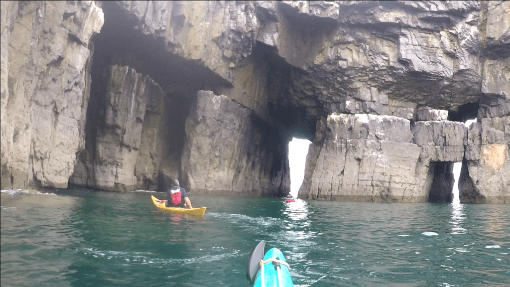
On the way back we took our time again and made the most of exploring the many caves, arches and rock gardens that we found.
It’s a great place for practicing manoeuvres and testing paddle strokes, looking for the movement of the water and, last but not least, being glad that you have a plastic, not composite boat when it doesn’t quite go to plan!
And finally heading back to the dramatic arches of Stackpole Head…
The trip back across the bay felt long, and once we’d rounded Trewent we felt the wind funneling down from the shore. I’ve felt this effect before: light winds can become much more than expected when they are channeled down a valley.
…and Finally
Definitely a trip to do again and next time maybe to get along under the cliffs by Castlemartin. Or maybe go the other way to Caldey Island.
A happy trip around Milford Haven in our sea kayaks
Cave on Lindsway Bay
Getting away
So, like two ageing hippies we set out in the VW Camper, hair still in lockdown style, Fleetwood Mac good and loud from the speakers. (No beads and bangles though). Two beautiful sea kayaks loaded onto the roof with much less hassle, back-ache and strap flapping now that we have a Kari-Tek Easy Load Roof Rack. Yep, having heavy boats to transport makes you into roof-rack anoraks. Sad but true.
Although Milford Haven doesn’t sound like an idyllic location, especially for those of us who remember the Sea Empress disaster in 1996, it is now a great spot for wildlife enthusiasts, water sports and even beaches (as long as you don’t want crowds or lots of space….)
We had a wonderful three days, made all the more poignant after months of limited travel. Read on for notes on our kayaking, wildlife and where to find chips.
Where did we go?
Pickleridge
We started (and finished) each trip at the beach north of Dale village (Pickleridge), which has the Pembrokeshire Coast Path running along its shore. The grid reference is SM 810068. It was much quieter than Dale itself which is a centre for watersports: paddle-boards, windsurfers, dive boats, yachts and kayaks. The beach at Pickleridge is a shingle beach with quite a carry over rocks and seaweed at low tide, so it’s worth planning to launch or return in the top couple of hours of the tide.
Pickleridge (Dale) at low tide
There is a great view across the harbour and at low tide you can see a wide variety of birds (and quite a few people with binoculars). Apart from them the beach was always quiet, even on these really warm August days. Just what we love.
Tuesday 11th August – Watch House Point
About 3 miles
Monk Haven
Itching to get the boats out, we set out for a little paddle and reached Watch Point before we knew it. I am often surprised at how far we go in the kayaks in quite a short time; when we looked back to Watch Point from Pickleridge, it looked much further than it felt. (It’s 1.6 miles each way). Hugging the coast, we felt quite a swell and I wasn’t keen to stay still too long. Anyone else ever felt sea-sick in a kayak? A little way along we reached Monk Haven with its startlingly red sandstone walls and castellated wall at its back that marks the boundary of the Trewarren estate. The cove is so small and so neatly carved from the cliffs that the whole beach looks as if it were designed by the hand of man. One of the things that we love about being in the kayaks is that not only can you get to places that are otherwise hard to reach, but the perspective from a small boat is wholly different. It wasn’t a hard paddle even in the breeze and returning against the ebbing tide, so it was a neat limber up for our next trip.
A note on geology
Approaching Monk Haven
Monk Haven
Monk Haven, returning to Dale
The rock formations along this stretch show dramatic folding and although there are superb red cliffs, some look more like limestone. Looking at the geological map of Pembroke, Milford Haven is clearly hewn from Devonian Old Red Sandstone which is 345 million years old. The fjord-like inlets and deep water channels of the port were formed in the ice age when rivers flowed under the ice sheet to form deep channels leaving a Ria or drowned river valley. (Here is a link that explains it much better! https://www.pembrokeshirecoast.wales/about-the-national-park/geology/geological-landscape/)
Wildlife in Dale
On our return went into the shallows of the river that flows down from Mullock. Curlews (and possibly whimbrels), Oyster catchers were in abundance, their haunting, ululating calls, filling the air like a film soundtrack. There were, of course, lots of gulls. Now, telling them apart isn’t easy, much simpler just to lump them together as seagulls. However, as my book says, the herring gulls is a ‘robust’ bird with a ‘familiar laughing display call’. Yep, lots of those. We also saw Common gulls, (Larus canus and rather smaller than the Herring Gull according to my book) but I don’t think they are as common as the Herring Gulls! There were also black-headed gulls and more interestingly (perhaps) I saw a few gannets – huge, elegant birds with notably pointed and slim wings. RSPB reports that they spend their lives at sea, but we are lucky to have breeding colonies in Pembrokeshire. I’m not sure of the official term for a group of gannets but the RSPB book was happy to describe them as ‘squadrons’, which fits rather nicely. I mustn’t forget the cormorants and Shags: we saw both, often in their classic wing-drying stance, but also perched on rocks. The Shag is about 20cm smaller than the cormorant which also has pale cheeks and the young birds have ‘dirty white underparts’.
In the shallows of the beach there were shoals of very fast-swimming fish. Although we were on an ebbing tide with a following wind (8-9mph Northerly) we had a pleasant paddle. The wind changed in places across the bay – noticeable in the fluorescent green race flags of the yacht club.
Chips!
Later we had a gentle wander round the bay into Dale. As a teenager I spent many happy evenings scrambling over rocks on the beach at Portishead, so scrambling around the waterline and peering into rockpools is a happy pastime. Covid restrictions mean that an unplanned meal out isn’t possible, but we managed to get some excellent takeaway chips and a good pint of ‘Tenby Harbour’ to enjoy on the beach. A balmy evening, a quiet beach, food and drink and the prospect of more lovely paddles. What more could we want?
Wednesday 12th August – Round Milford Haven
11.5 miles
Loving our ‘Welsh Sea Kayaking: Fifty Great Sea Kayak Voyages’ book we picked number 40 which plots a journey around Milford Haven, starting at Dale. We were later than the suggested 2 hours after low water, nonetheless we had a superb trip and no long carries (always good news with Two Tonne Tess, the Scorpio).
Don’t Rock the Boat
The trip was 11.5 miles and my first real adventure in the boat. We tootled round in just over 4 hours with a 15 minute stop at East Angle Bay, a few moments of rafting up to wait for tankers and a little interlude to look at two ocean rowing boats. Never having seen one close to I was curious. These two were moored to the pontoon at Dale harbour – one in blue, the other red – and both emblazoned ‘Don’t Rock the Boat’. Equipped with multiple Marshall cameras it was clear that the three rowers were going to be under constant and full surveillance. The craft looked pristine, so we guessed that they were early in their journeys. We later discovered that we had just missed Freddie Flintoff and the crew shooting for an ITV show in which celebrities take on a 500 mile rowing trip and some challenges at various points between Lands End and John O’Groats.
Crossing over to Angle
As we left the shelter of the bay we felt the swell in the channel and once again I was grateful for the stability of the Scorpio. Looking out across towards Angle and Thorn Island I suddenly felt nervous – for the first time I felt I was heading out into open waters, away from hugging the coast. We had great visibility from here and could see the cardinal buoys and our destination coast clearly. Watching to our left (looking East) we spotted a pilot boat and tanker. Milford Haven, although a less busy port these days, still has a lot of shipping. According to the Gleeds website,( https://gb.gleeds.com/projects/milford-haven-gas-plant/) the UK is increasing its need for imported LNG as North Sea gas decreases. Milford Haven is one of the busiest LNG terminals in the world and in our day trip we saw 3 tankers coming or going. It is also the route into Pembroke Dock for ferries crossing over to Rosslare. Don’t think we’ll tangle with those unmanoueverable, water juggernauts. All this means that it is crucial to keep an eye on what is happening and to cross the shipping lane at 90 degrees and without hanging around. Whilst we are used to crossing the road and judging speed of vehicles, it was a different matter for ships, so although the tanker looked a way off, we decided to raft up and wait. We didn’t wait for very long…..
Waiting for the traffic
From Dale it is hard to see the definition of Thorn Island as the coast merges in the distance with Angle. Once close we could see it wasn’t huge and paddled around the back, passing a few paddle boarders and a kayak who had come out from the nearby West Angle Bay.
Heading from Dale to Angle
Going between Thorn Island and Angle
Crossing the shipping lane from Dale to Thorn Island
East Angle Bay
From there we headed East around the Angle coast towards Chapel Bay and the lifeboat station. Although we had the refinery ahead of us and the LNG jetties to the left, this was a lovely paddle on clear aquamarine waters. Still near the top of the tide we were able to paddle south into East Angle Bay (lots of exposed mud and sand at low tide!), where we took a breather and a much needed leg stretch. It would have been lovely to have an ice cream but no luck and we weren’t in pub mode (though the Point House Inn is on the list for another trip).
Lifeboat station, Angle
East Angle Bay
Shallow!
Old Point House Inn
East Angle Bay
Stack Rock Fort
From there we headed back out towards the jetties and headed NW towards the fort on Stack rock. Apparently there are sometimes seals there, but they were hiding from us. It looked like an interesting place to land and explore, but there are notices forbidding it… The fort is privately owned and was first built to defend the Royal Dock (Pembroke Dock) in 1850-1852. The first floor was used as a gun deck, the second housed 30 men. It was decommissioned in 1929.
Stack rock Fort
From the fort we headed over to Great Castle Head (missing out the trip to Sandy Haven Pill) and then followed the coast back and across to Pickleridge. This last stretch only had very light north-easterly winds but on an ebbing tide in 28 degrees at the end of our trip it felt like hard work.
Storms gathering
The storms forecast for the week started building in the evening and as we sat in the dimming light we were treated to an amazing spectacle of electricity building within a classically anvil-shaped cumulo nimbus cloud. It was like something from a sci-fi film. Gradually increasing sheets of light would burst into the cloud and then crack into forks of lightning.
Cumulo Nimbus generating electricity
Thursday 13th August – Watwick
5.5 miles
After a hot and sunny day doing the Milford Haven tour, we decided on a shorter paddle for our last day. (Note to self, I need to find a cushion of some sort for longer paddles in the Scorpio!) The weather forecast was for possible thunder storms later so we decided to do a short trip which allowed for a quick return. As it turned out, the weather was lovely and we set out from the bay in millpond conditions.
More forts
We hugged the coast and paddled into Dale, round the many moored yachts. Still, the beach was almost empty in the morning with little watersports activity either. Heading out to Dale point, under the fort we felt some swell again, maybe from large shipping’s wake through the channel. The fort, built in around 1858, was part of a set of forts with West Blockhouse and Thorn Island which provided interlocking fire to protect the anchorage in Milford Haven. It is now an active field studies centre.
Milford Haven’s hidden gem?
We continued in calm but slightly swelly waters, hugging the coast of Castlebeach bay and then on round to the amazing sight of the sands at Watwick.
Approaching Watwick
Watwick Bay
Not quite Bournemouth Beach!!Watwick
Another lesson learned here – don’t take the spray deck off until you are out of the waves. I got rather wet……. Still, the beach was empty, so at least I could put some things to dry on the rocks. We could have been on some ridiculously expensive holiday, perfect sand, clear water, no people and sea that was warm enough for a swim without a wetsuit.
Perfect…
Swimming
After such a lovely interlude, we didn’t go too far, just on out to West Blockhouse point from where we got a good view of St Ann’s head. Seven miles south-east of St Ann’s head are the reefs of Crow Rock and Toes which have claimed many ships. In 1714 there were two leading lights to guide shipping with the lighthouse replacing those in 1844. It was ‘demanned’ and automated in 1998 with the buildings around it now set up as holiday lets. (https://www.trinityhouse.co.uk/lighthouses-and-lightvessels/st-anns-head-lighthouse)
A great place to paddle
We found Milford Haven much more aesthetic than we’d expected and were also very happy to find a quiet place. 2020 has seen hoards of ‘staycationers’ flocking to beaches and pictures of crowds on the south coast have been shocking. We’ve been looking for places to paddle where we can find space, shelter for less clement weather and somewhere to unwind. This ticked all the boxes.
What next?
Broad Haven and Little Haven were very busy and we couldn’t even get chips in the former. A trip to St Martin’s have to look at a launch site showed us a small bay, which was catching all the weather when we were there, but there are some good looking trips around the western side of the point – all for another day.
As I write, we are entering our 4th week of the Corona virus lockdown.
I am an optimist and I believe that looking forwards is healthy and that looking back, whilst providing opportunities for reflection, for learning and for re-lived joy, can also lead us into thinking about the things we are missing. That in turn can spark little embers of sadness. Particularly at this time, I don’t want to go there.
So, let’s look at how we can meld the two together to make sure that when the chance arrives, we are not left thinking that we have missed our chances.
Using the past to make our futures
Don’t get me wrong, memory is a valuable thing and remembering what we have done and seen in the past informs our decisions for the future. So, for example, I know that one of the things that will bring me real joy and a sense of satisfaction is completing a challenging, multi-day trip in the kayaks. I know that I will be awed by amazing scenery, fascinated by local history and made to smile by spotting wildlife.
Scottish Wildlife – Nessie?
So, my first link from past to future:
Scotland. That place of amazing scenery, terrible midges and more rain that you could ever want. (Yes, even more than Wales I think). Specifically, the Great Glen – that huge rift which splits Scotland from coast to coast.That’s where I want to go.
I’ve had many, many memorable trips to Scotland, so I see it as a happy place – even in the most inclement weather. My husband proposed to me on the top of The Pap of Glencoe, so that has to be a top memory, but Scotland has also been the scene of some of my own, personal (sporting) achievements. Among many others are: we have walked amazing ridges (Aonach Eagach); caught a train after a two minute wait (and no timetable!!) from the most remote station I’ve ever visited; we ice-climbed on Buachaille Etive Mor, we’ve camped in Winter and celebrated Hogmanay at the Clachaig Inn. I’ve walked solo in the Arrochar Alps and spent happy childhood holidays in Mallaig, Oban, Fort William and the islands. Conversely we’ve had long walks in the Grey Corries and stayed in bothies, we’ve dealt with a broken ankle and spent time in A and E in the Belford hospital. We’ve had holidays where it has rained and blown a gale, putting paid to any number of plans – BUT – Scotland is still a happy place. So, memories tell me that we should go, make a plan A (and possibly B and C too!), because we will have a memorable time.
Rain will not deter us (midges might!)
My second link from past to future is:
I know I’m not in a position to paddle the length of the Great Glen now, but by the time we go, I will have made preparations that build my confidence, my skills and my knowledge, I will know where we start and finish and I’ll have researched places and history that will ensure that it is a memorable trip for the right reasons!
Feeling motivated….
The maps…..
I love maps. I can spend ages looking at them – especially the OS ones. They tell you so much and even provide pointers to history. Scotland’s OS maps are some of the best value (far more contour lines per page than any other), but also the worst value (all that sea around the islands). At this point, I could so easily digress to looking at the history of our beloved Ordnance Survey maps, but that is, perhaps, a thought for another stage in my Great Glen trip planning. It is said that we might enthuse others, but we can only motivate ourselves, so again, thinking back, I realise that garnering heady detail on the things which bring a country, its geography and its history to life will bring me the enthusiasm to research more. I love to have things in 3D – not always literally, but through understanding background and what make things and people what or who we see in the present.
Recognising our boundaries
I used to think I was quite happy being independent and likened that to being solo and to some extent that remains true – I’m not a real party animal. However, when I left the corporate world to work for myself I suddenly started to see what connections with other people can do for us. It isn’t always about asking for help, but it’s about sharing experience, seeing where perspectives coincide or diverge and to learn from others. I’m not sure if it’s a British thing, but sometimes we are shy about asking. Asking anything at all. The real truth is (as I have discovered through coaching people) is that most people enjoy sharing things about themselves, they love to tell you about their adventures, how they made them happen and what a great time you could have too. This is important. We learn to value other people and to get to see things differently. It helps us to draw our own boundaries and to recognise where we are in a greater scheme of things. There’s no judgement, it’s just placement.
Engaging and connecting
Like it or hate it, Facebook is full of opinions and if you can filter what you engage with, it’s a great place. Ask for recommendations or information and you will get plenty of replies. You’ll ‘meet’ new people (and here we are, in a new world where virtual meetings, virtual friends, virtual conversations are becoming more normal). So, I’m intending to share my planning for this trip with you and, not so much to get everyone going to the same place (please no!!), I’ll share links with the people and groups who have interacted with my questions and helped to encourage me to make this trip happen. The only thing I won’t be able to do is set a date. But let’s not allow that to get in the way.
Lovely new toy just waiting for some water
GREAT GLEN HERE WE COME WITH OUR KAYAKS!
Here are some of the links that are enthusing me, keeping me going or just making me smile at present:
UK Kayakers and canoeists – a great FB group, well moderated and with a variety of members.
West Coast Paddlers – a private group but I found this when asking about the Great Glen trip and I had a lovely answer and pointer to a useful trip report.
World Backyard Rolling Championships – nothing at all to do with the trip, but inventive, creative and a bit of fun for Spring 2020. (2008 members in just 20 days, must tell you something!)
Maps – website. One of my favourites. You can look at road view or OS view and you can measure distances point to point. Brilliant fun and far too many hours browsing this!




 AC Canoe Adventures